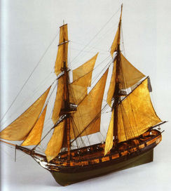
Il Mercurio affondò il 22 febbraio 1812 in seguito all’esplosione della Santa Barbara probabilmente per un colpo fortuito proveniente dal brigantino Weasel da cui era stato attaccato.
Lo scontro si svolse nel corso della battaglia di Grado combattuta tra una squadra italo francese e una squadra britannica non appena la prima, composta dal vascello francese Rivoli e da altri due brigantini, era uscita dal porto di Malamocco per una missione di scorta del vascello francese Rivoli al suo viaggio inaugurale.
L'esplosione, al largo di Punta Tagliamento, causò lo stacco e l’affondamento della poppa, mentre il resto del brigantino continuò la sua corsa per affondare a meno di cento metri.
Il sito venne scoperto da un peschereccio della famiglia Scala nel 2001 e venne indagato tra il 2004 e il 2011 dall'Università Ca 'Foscari di Venezia, in collaborazione con la Soprintendenza Archeologica del Veneto. Il relitto si è dimostrato da subito un contesto di notevoli potenzialità. Si presenta diviso in due zone: l’Area A, che comprende la porzione principale della prua dello scafo (lungo 16 m) e l’Area B costituita dal dritto di poppa. L’indagine si è concentrata sul lato sinistro della prua, all’interno della struttura lignea dello scafo. La quantità e la qualità delle condizioni conservative dei manufatti, molti anche in materiale organico, fanno del Mercurio uno dei relitti meglio conservati del Mediterraneo.
Centinaia di reperti (armi da fuoco, armi bianche, equipaggiamento nautico, attrezzatura dello scafo, oggetti della cambusa, attrezzi, scarpe e bottoni delle uniformi, oggetti personali e resti di alcuni scheletri) sono stati recuperati dal sito, mentre alcuni oggetti di grandi dimensioni sono stati lasciati in situ con lo scafo.
L'ampia documentazione realizzata ha permesso di creare un modello digitale 3D in cui, presso il Museo Nazionale dell'Archeologia del Mare di Caorle, è possibile immergersi virtualmente. Oltre a questa postazione il museo offre altre installazioni multimediali ed un’esposizione dei manufatti restaurati.
Brig Mercurio sank on February 22, 1812, for the explosion of the Santa Barbara probably due to a fortuitous attacked from the brig Weasel. The collision took place during the battle of Grado between the Italian-French fleet, composed by the French vessel Rivoli and two other brigs, and the British fleet, as soon as the first one had left the port of Malamocco during the maiden voyage of the French vessel. The explosion, off Punta Tagliamento, caused the detach of the stern and its sinking, while the rest of the brig continued its run to sink less than a hundred meters far away.
The site was discovered by fishermen Scala in 2001, while it was investigated between 2004 and 2011 by a team from the Università Ca’ Foscari of Venice, directed by Carlo Beltrame, in collaboration with the Soprintendenza Archeologica of Veneto. The wreck has been identified in two zones: the Area A of the large portion of the stem part (16 m long) of the brig and the sternpost of the ship. The investigation focused on the left side because the heeling of the hull on this side created the perfect environment for the conservation of many objects inside the wooden structure. The quantity of the objects preserved and the quality of the conservation conditions of the artefacts, many on which are organic material, allow to Mercurio becoming one of the best-preserved wrecks in the Mediterranean.
Hundreds of finds (artillery, hand arms, nautical equipment, metal parts of the hull, pottery and other objects from the galley, repairing tools, shoes and buttons from the uniforms, personal objects and skeletons remain) were recovered from the site, but some large items were left in situ with the wooden hull, which was partially exposed on the portside.
The wide documentation realized during the campaign consist in maps and in a GIS of the wooden elements, the artefacts and the artillery and in a virtual 3D photogrammetric model realised on legacy data. The objects are exposed in the Museo Nazionale dell’Archeologia del Mare of Caorle, where multimedia stations have been installed, with VR, touch screen and 3D models. The archaeological site is partially visible underwater, but the area is restricted.


